 vesseltracker.com
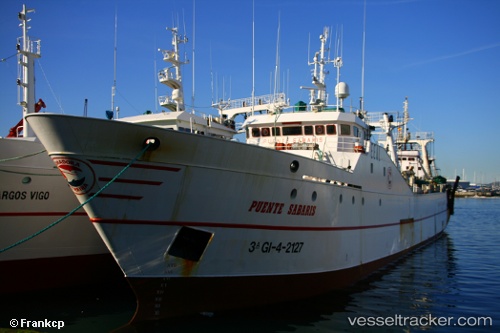
Vessel PUENTE SABARIS IMO: 8509210, MMSI: 601893800 Fishing Vessel
UTC, -34.50667, 25.48667, course: -1, speed: 4
UTC, -34.49621, 25.61724, course: 270, speed: 10.2
2026-02-04 11:37:12 UTC, -34.49833, 25.52167, course: -1, speed: 3
Live AIS position:
UTC. 30 nm S of Mount Pleasant),
updated 2026-02-04 11:37:12 UTC.
Find the position of the vessel PUENTE SABARIS on the map. The latter are known coordinates and path.
marine traffic ship tracker show on live map
The current position of vessel PUENTE SABARIS is -34.49833 lat / 25.52167 lng. Updated: 2026-02-04 11:37:12 UTCCurrently sailing under the flag of South Africa
PUENTE SABARIS built in 1986 year
Deadweight:
1216 tDetails:
Last coordinates of the vessel:
UTC, -34.52223, 25.44460, course: 73, speed: 4.8UTC, -34.50667, 25.48667, course: -1, speed: 4
UTC, -34.49621, 25.61724, course: 270, speed: 10.2
2026-02-04 11:37:12 UTC, -34.49833, 25.52167, course: -1, speed: 3